
En los últimos años, el concepto de un gemelo digital de una ciudad se ha convertido en un tema central en la planificación urbana, análisis geoespacial y estrategias de ciudades inteligentes. El término es ampliamente utilizado por arquitectos, autoridades municipales y proveedores de tecnología. Sin embargo, a menudo se refiere a soluciones muy diferentes, que varían desde visualizaciones 3D simples hasta sistemas analíticos complejos para modelar procesos urbanos.
Este artículo explica qué es realmente un gemelo digital de una ciudad, cómo ha evolucionado a partir del SIG tradicional, qué lo distingue de los modelos 3D de ciudades, y por qué los datos y la analítica son más importantes que el detalle visual.
De mapas a gemelos digitales urbanos
La evolución de los sistemas de geoinformación ha sido gradual y acumulativa. Primero, los mapas se hicieron digitales e interactivos. Luego pasaron a plataformas web, permitiendo acceso y actualizaciones colaborativas. Con el tiempo, los proyectos de SIG comenzaron a incorporar paneles de análisis, datos temporales y representaciones tridimensionales.
Como resultado, los mapas dejaron de ser ilustraciones estáticas y se convirtieron en entornos de trabajo para análisis y toma de decisiones.
En este contexto, la idea de un gemelo digital urbano aparece como una continuación lógica del desarrollo del SIG. Refleja la necesidad de combinar la geometría de la ciudad, conjuntos de datos heterogéneos y herramientas analíticas en un único sistema que apoye la simulación y la previsión.
¿Qué es un gemelo digital de una ciudad?
Un gemelo digital de una ciudad es un sistema geoespacial, impulsado por datos, que vincula modelos espaciales con herramientas analíticas y de previsión para simular, analizar y comparar escenarios de desarrollo urbano.
A diferencia de un modelo visual creado para fines de presentación, un gemelo digital está diseñado para análisis continuo y soporte a la toma de decisiones.
Un gemelo digital de ciudad típico incluye:
Capas espaciales que representan edificios, redes de transporte, servicios públicos, uso del suelo y espacios públicos
Datos de atributos y estadísticos que describen parámetros sociales, económicos y ambientales
Una dimensión temporal que permite a los usuarios rastrear cambios a lo largo del tiempo
Herramientas de modelado y comparación de escenarios para evaluar decisiones de planificación y políticas
Si estos elementos existen de manera independiente, el sistema sigue siendo un mapa o un modelo 3D. Un gemelo digital surge solo cuando la geometría, los datos y la analítica están estrechamente conectados.
Gemelo digital vs SIG vs Modelo 3D de ciudad
Entender las diferencias entre estos conceptos es esencial para expectativas realistas.
Característica | SIG | Modelo 3D de ciudad | Gemelo digital |
Datos espaciales | Sí | Sí | Sí |
Datos de atributos | Sí | Limitado | Sí |
Dimensión temporal | Limitada | No | Sí |
Simulación de escenarios | Rara | No | Sí |
Soporte a la toma de decisiones | Parcial | No | Función principal |
Un gemelo digital no reemplaza al SIG. En cambio, se basa en las capacidades del SIG y las extiende con análisis temporales, simulación y previsión.
Los datos como la base de un gemelo digital de ciudad
Cualquier gemelo digital es tan útil como los datos que lo respaldan. Las fuentes de datos centrales suelen incluir conjuntos de datos catastrales y topográficos, registros municipales, imágenes de teledetección y portales de datos abiertos. En algunos casos, se añaden datos de sensores relacionados con el transporte, servicios públicos o monitoreo ambiental.
Sin embargo, los datos en tiempo real no son obligatorios. Muchas tareas de planificación urbana se pueden resolver de manera efectiva utilizando conjuntos de datos actualizados periódicamente combinados con análisis históricos y modelado de escenarios.
El factor crítico no es el volumen de datos, sino la relevancia, consistencia y lógica de actualización de los datos.
Ejemplos reales de gemelos digitales de ciudades
Singapur Virtual
Singapur Virtual es uno de los ejemplos más citados de un gemelo digital de ciudad. Combina una geometría detallada de la ciudad en 3D con datos demográficos, ambientales y climáticos. El sistema se utiliza para analizar la densidad de edificios, la exposición solar, los flujos peatonales y escenarios de respuesta a emergencias antes de que se implementen cambios en la ciudad real.
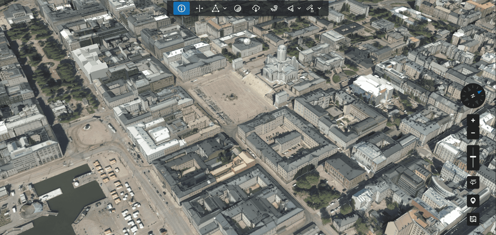
Helsinki 3D+
El modelo digital de ciudad de Helsinki apoya la planificación urbana, la investigación climática y el compromiso público. El acceso abierto a los datos permite a residentes, investigadores y urbanistas explorar juntos escenarios de desarrollo, convirtiendo al gemelo digital en una herramienta de transparencia y participación, no solo de análisis interno.
Gemelo Digital de Rotterdam
Rotterdam está desarrollando su gemelo digital para gestionar un entorno urbano y portuario complejo. El sistema integra edificios, infraestructura de transporte, servicios públicos y sistemas de agua. Se utiliza para simular riesgos de inundación, probar cambios en la infraestructura y evaluar estrategias de adaptación al clima en una ciudad donde grandes áreas se encuentran por debajo del nivel del mar.
¿Quiénes utilizan gemelos digitales de ciudades?
Los gemelos digitales de ciudad son utilizados principalmente por:
Urbanistas y arquitectos
Autoridades municipales y regionales
Operadores de infraestructura y servicios públicos
Desarrolladores e inversionistas inmobiliarios
Analistas de riesgo ambiental y climático
Para cada grupo, el valor radica en la comparación de escenarios y la reducción de riesgos, no en el realismo visual.
Limitaciones y una perspectiva crítica
A pesar de su popularidad, muchas iniciativas de gemelos digitales no logran ofrecer valor a largo plazo. Los problemas comunes incluyen datos desactualizados, casos de uso poco claros y un énfasis excesivo en la presentación visual.
Las limitaciones clave incluyen altos costos de implementación, integración de datos compleja y una falta de experiencia analítica dentro de las organizaciones. Sin una cultura de trabajo con datos y modelos geoespaciales, los gemelos digitales rápidamente se convierten en vitrinas estáticas.
En muchos casos, invertir en calidad de datos, flujos de trabajo analíticos y capacitación de usuarios es más importante que construir un modelo 3D detallado.
¿Por qué son importantes los gemelos digitales en la planificación urbana?
Más allá de la terminología de marketing, los gemelos digitales representan un intento de integrar tecnologías de geoinformación y planificación urbana en un único marco analítico. Su propósito principal es ayudar a los especialistas a entender la dinámica urbana, evaluar caminos de desarrollo alternativos y tomar decisiones basadas en evidencia espacial en lugar de suposiciones aisladas.
Un gemelo digital es, en primer lugar, una herramienta de previsión y análisis. Su valor se determina no por la complejidad visual, sino por la calidad de las preguntas que ayuda a responder.
Preguntas frecuentes
¿Existe un gemelo digital universal de una ciudad?
No. La estructura y el nivel de detalle dependen de objetivos específicos, datos disponibles y capacidad institucional.
¿Se requiere visualización 3D para un gemelo digital?
No. Muchas tareas de planificación y análisis pueden resolverse utilizando mapas 2D combinados con datos y análisis temporales.
¿Requiere un gemelo digital datos en tiempo real?
No necesariamente. Conjuntos de datos actualizados regularmente son suficientes para la mayoría de los escenarios de planificación urbana.
¿Qué problemas resuelve mejor un gemelo digital de ciudad?
Comparación de escenarios, planificación de infraestructura, evaluación de riesgos climáticos y análisis de desarrollo a largo plazo.
Conclusiones clave
Un gemelo digital de una ciudad es un sistema analítico y predictivo basado en datos geoespaciales.
Su efectividad depende de tareas claramente definidas y datos confiables.
Comenzar con casos de uso y escenarios es más importante que comenzar con un modelo.


