
En el entorno minorista altamente competitivo de hoy, las empresas están constantemente buscando nuevas formas de mejorar la eficiencia y atraer a más clientes. Una de las herramientas más poderosas que permite esta transformación son los Sistemas de Información Geográfica (SIG).
Tradicionalmente utilizados en la planificación urbana, la logística y el monitoreo ambiental, los SIG ahora están desbloqueando un inmenso valor en el sector minorista, desde la ubicación de tiendas hasta la optimización de la cadena de suministro y el compromiso hiperlocal con los clientes.
¿Qué son los SIG y cómo funcionan?
Los Sistemas de Información Geográfica (SIG) son tecnologías diseñadas para recopilar, analizar y visualizar datos espaciales (basados en ubicación). Permiten a las empresas trabajar con información vinculada a coordenadas geográficas específicas, proporcionando una profunda comprensión de los patrones y relaciones espaciales.
Funciones centrales de los SIG:
Recopilación de datos: Densidad de población, infraestructura, redes de transporte, tráfico peatonal.
Análisis espacial: Identificar patrones como zonas de accesibilidad o puntos calientes competitivos.
Visualización: Crear mapas dinámicos y paneles de control geoespaciales para informar decisiones.
Cómo los minoristas utilizan los SIG para impulsar el negocio
Las aplicaciones de SIG en el comercio minorista son vastas y están en crecimiento. Aquí hay algunas de las formas clave en que las empresas minoristas utilizan la inteligencia de ubicación:
Selección del sitio de la tienda
Elegir la ubicación correcta es una decisión estratégica crítica. Los SIG ayudan a los minoristas a analizar el tráfico peatonal, la demografía de la población, los niveles de ingresos, las ubicaciones de los competidores y las rutas de transporte para encontrar áreas de alto potencial.
Segmentación de clientes por ubicación
Los minoristas utilizan los SIG para entender qué tipos de productos están en demanda en vecindarios específicos y personalizar las ofertas de la tienda en función de las preferencias locales.
Optimización de la logística
Los SIG pueden mejorar las rutas de entrega teniendo en cuenta las condiciones de las carreteras, las distancias y los centros de distribución, reduciendo el tiempo de envío y los costos de transporte.
Planificación de inventarios y surtidos
Los SIG ayudan a predecir la demanda local y los patrones de estacionalidad, reduciendo el riesgo de sobrestock o falta de productos específicos.
Ejemplo real: Walmart e inteligencia de ubicación
El líder minorista global Walmart utiliza SIG avanzados y análisis de ubicación para refinar las ubicaciones de tiendas, las redes de distribución y la información sobre los clientes. Así es como:
Selección de sitio inteligente
Walmart integra datos demográficos, socioeconómicos y de competidores en plataformas SIG para identificar ubicaciones óptimas para tiendas y evitar la canibalización del mercado.
Mapeo del comportamiento del cliente
Con los SIG, Walmart puede analizar los hábitos de compra, identificar áreas desatendidas y optimizar la publicidad por región.
Análisis de la cadena de suministro en tiempo real
Los SIG mejoran la visibilidad de la cadena de suministro de Walmart, mejorando la planificación de inventarios y la eficiencia logística en operaciones globales.
Al aprovechar los conocimientos geoespaciales, Walmart asegura la excelencia operativa mientras mejora la experiencia del cliente en todos los niveles.
GISCARTA: Una poderosa plataforma SIG para la inteligencia minorista
GISCARTA es una plataforma SIG moderna basada en la web diseñada para resolver desafíos empresariales reales a través de análisis geoespaciales y herramientas de mapeo inteligente. Los minoristas utilizan GISCARTA para agilizar la toma de decisiones en planificación de ubicación, logística, marketing y operaciones.
Características clave para el comercio minorista:
Análisis de transporte: Analizar accesibilidad, zonas de tiempo de conducción y optimización de rutas.

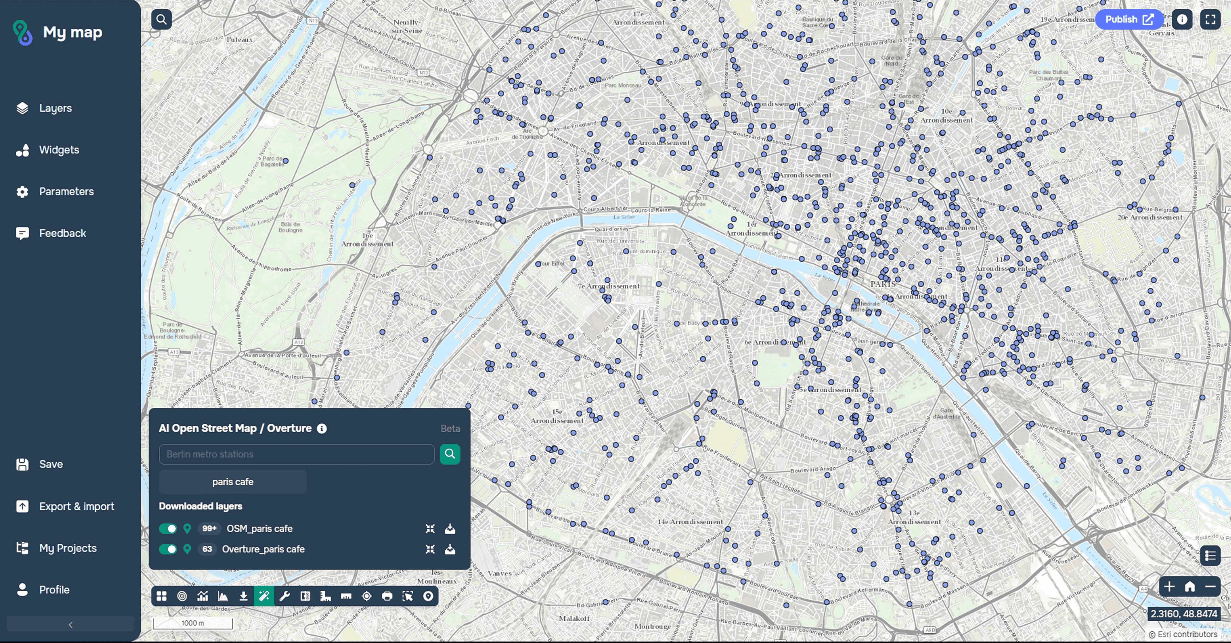
Geodata AI: Extraer instantáneamente conjuntos de datos de código abierto (como OSM y Overture) para análisis.
Paneles dinámicos: Visualizar el rendimiento por ubicación en tiempo real.
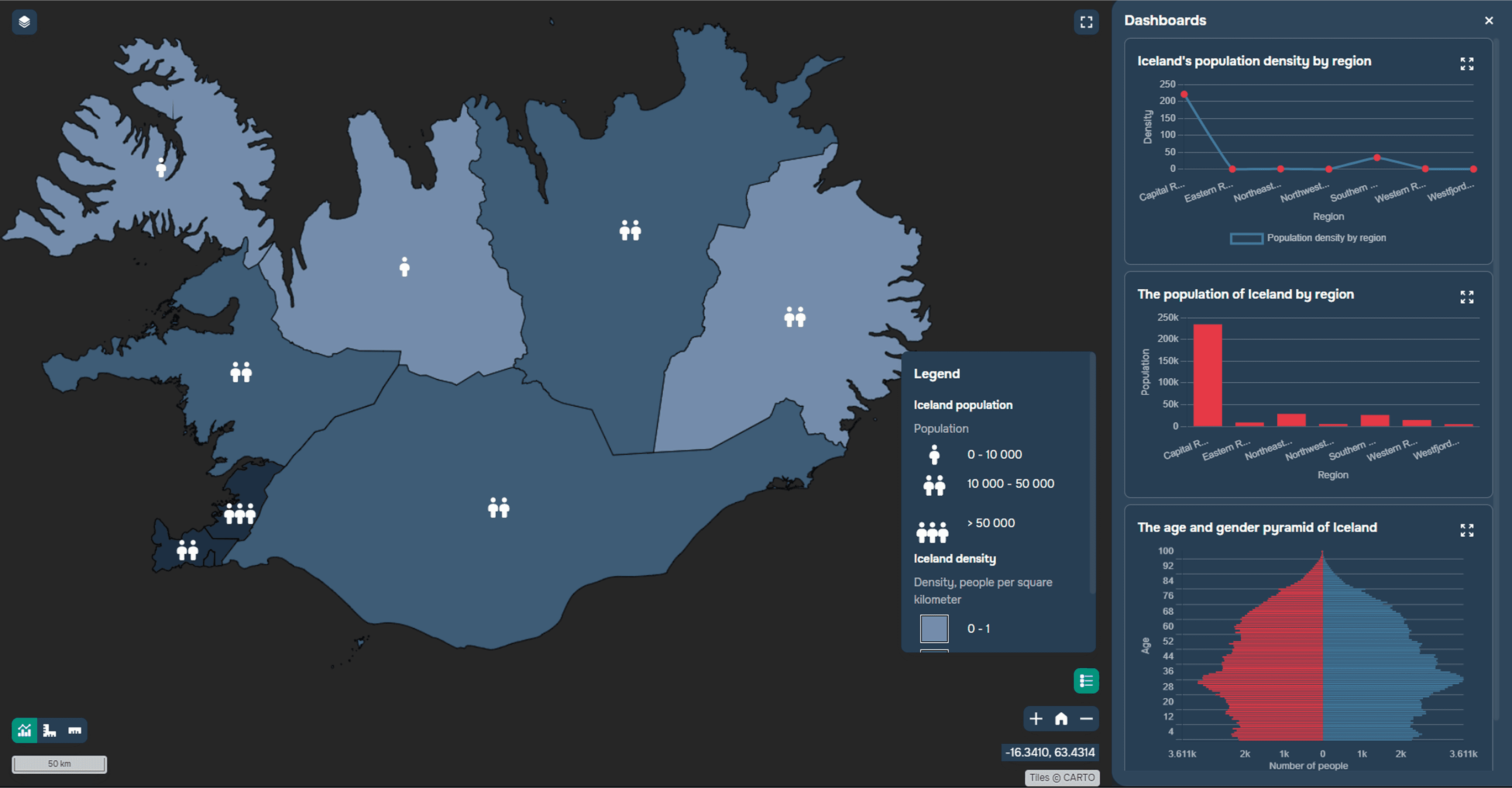
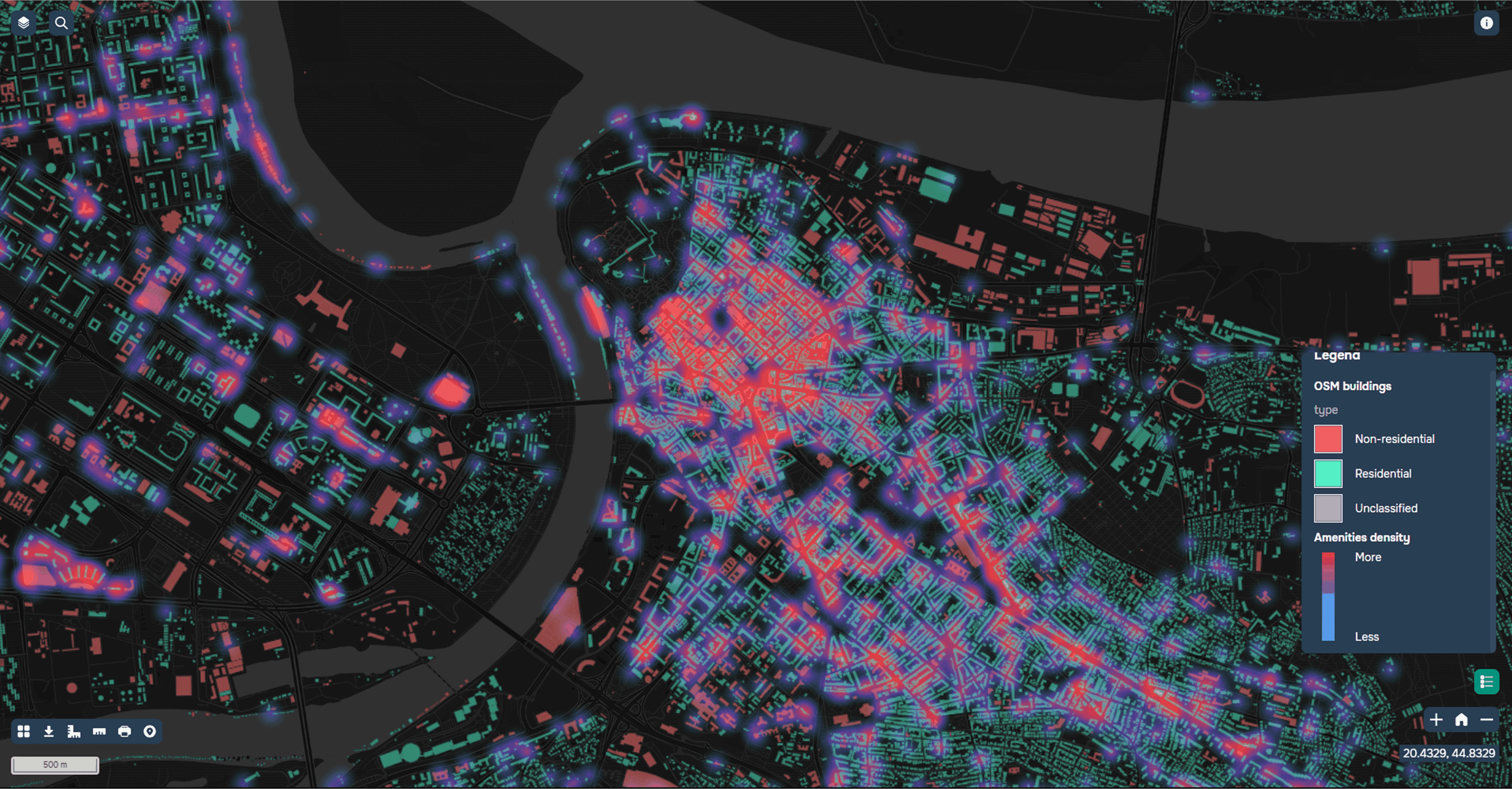
Mapas de calor y comparación de capas: Comparar fácilmente conjuntos de datos y resaltar áreas de alta demanda.
Herramientas de deslizador de tiempo: Analizar cómo evolucionan las dinámicas espaciales a lo largo del tiempo.

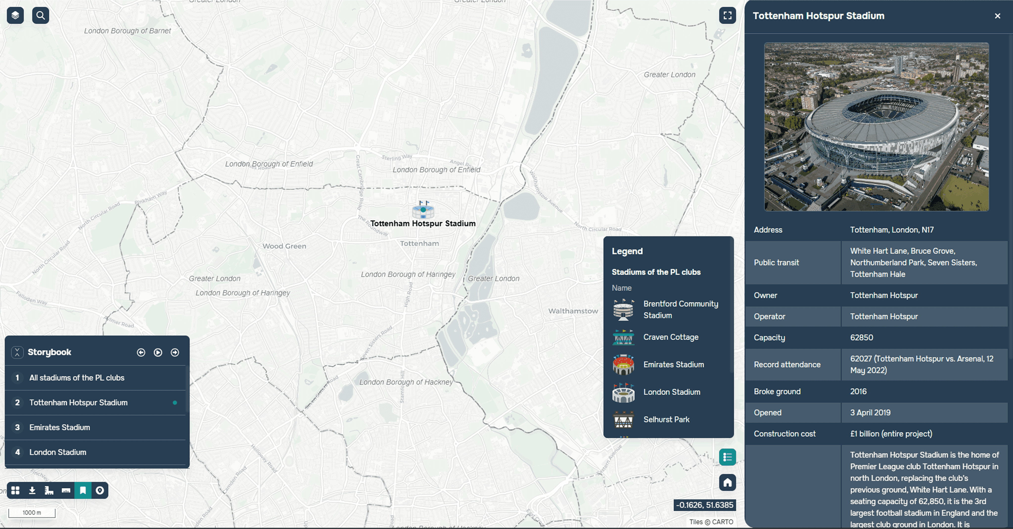
Historias de mapas personalizadas: Convertir datos espaciales en narrativas visuales atractivas.
Colaboración con Positio
GISCARTA colabora con Positio, una empresa líder en inteligencia de ubicación de Argentina, para ofrecer análisis espaciales avanzados, perfilado de clientes impulsado por aprendizaje automático y pronóstico de sitios para marcas minoristas en todo el mundo.
Aprenda más sobre cómo GISCARTA puede apoyar su negocio minorista contactándonos aquí.
¿Por qué los SIG son el futuro de la estrategia minorista?
Empresas como Walmart ya están demostrando que los SIG son más que solo mapas; son un motor estratégico para el crecimiento. Desde ayudar a pequeños emprendedores a elegir una ubicación de recogida basada en ganancias proyectadas hasta guiar a gigantes globales en la apertura de tiendas de alto rendimiento, la inteligencia de ubicación se está convirtiendo en una función empresarial central.
Los minoristas que adoptan los SIG obtienen una ventaja decisiva: comprenden mejor sus mercados, optimizan operaciones y ofrecen experiencias de cliente más personalizadas, todo con datos espaciales como su brújula.


