
Forests play a key role in maintaining ecosystems, regulating climate, and the economies of many countries. At the same time, they are subject to constant impacts, including logging, fires, climate change, and soil degradation. Managing such complex systems requires accurate data and regular monitoring. Geographic information systems (GIS) address these challenges by combining spatial data and analytical tools.
Forests cannot be analyzed as static objects. Their condition is constantly changing, so it is important to consider both the spatial distribution and the dynamics of processes.
GIS are used to work with various types of data:
satellite imagery
forest inventory data
digital elevation models
climate parameters
This combination allows us to analyze forests as a system in which vegetation, topography, and climate are interconnected.
Forest Monitoring
One of the key applications of GIS is monitoring. These systems allow us to track changes in forest cover, identify degradation, and analyze trends over time. Satellite data can be used to:
record changes in forest area
assess vegetation health
monitor the impact of natural events
Indices such as NDVI allow one to assess vegetation health and identify areas of disturbance.
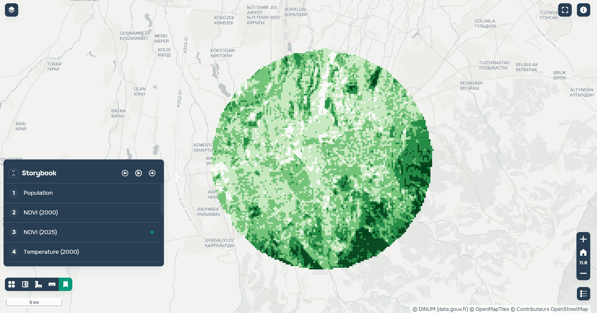
NDVI index for Almaty in 2025. Created using GISCARTA.
Forest Resource Analysis
GIS is used to assess forest resources and their distribution.
These systems allow one to:
determine forest area
analyze forest density and types
assess resource availability
This is important for planning harvesting and sustainable forest management.
Detecting Deforestation
Monitoring deforestation is one of the most in-demand tasks. Comparing satellite data over different periods allows one to identify changes and record forest loss.
Such systems help:
detect illegal logging
assess the scale of deforestation
monitor changes over time
This is especially important for the protection of natural areas.
Forecasting and Modeling
GIS allows one not only to analyze the current situation but also to predict future processes. Spatial analysis can be used to model:
forest fire spread
forest growth and restoration
the impact of climate factors
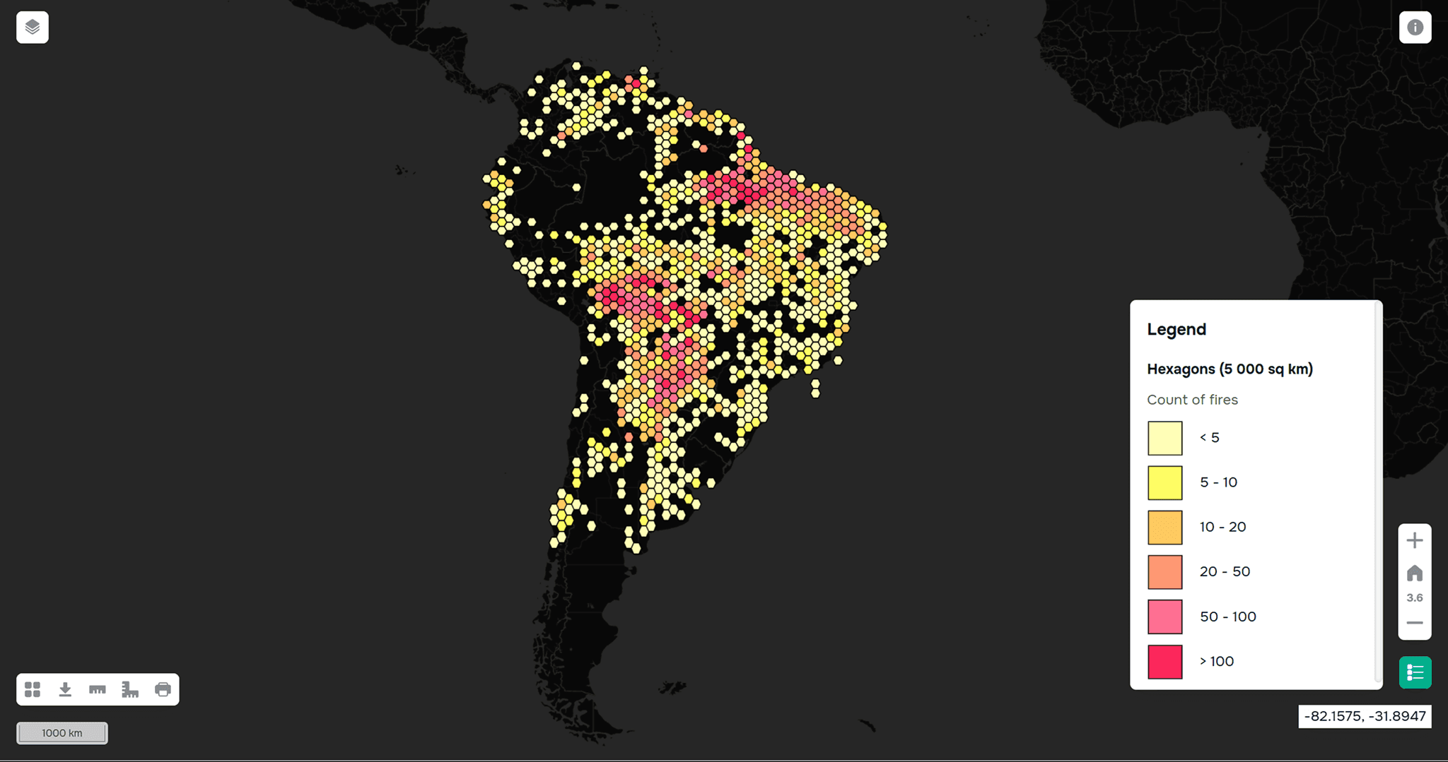
Distribution of fires across South America. Created using GISCARTA.
Such models are used for management decision-making.
Practical Applications
GIS is actively used in various forestry applications, enabling not only data analysis but also specific management decisions.
Deforestation monitoring is accomplished by comparing satellite data over different periods. This allows for the rapid identification of changes, recording forest loss, and detecting illegal activity.
In forest resource management, GIS helps plan timber harvesting, taking into account the spatial distribution of forests, their condition, and accessibility. This approach helps reduce the burden on ecosystems and support sustainable resource use.
In forest fire management, systems are used to assess fire risk and analyze fire spread. Factors such as topography, climate conditions, and vegetation type are taken into account.
GIS is also used in forest restoration. Analysis helps identify areas most suitable for reforestation and evaluate the effectiveness of restoration efforts over time.
Data Sources
Various data sources are used for analysis.
Satellite:
Copernicus: surface and vegetation data
Landsat: long-term observations
Environmental:
Global Forest Watch: deforestation and forest data
Geodata:
OpenStreetMap: basic infrastructure
Climate:
ERA5 / Copernicus Climate Data Store: temperature, precipitation
Data quality directly impacts the accuracy of the analysis.
Analysis Methods
Various GIS analysis methods are used in forestry:
NDVI and other vegetation indices
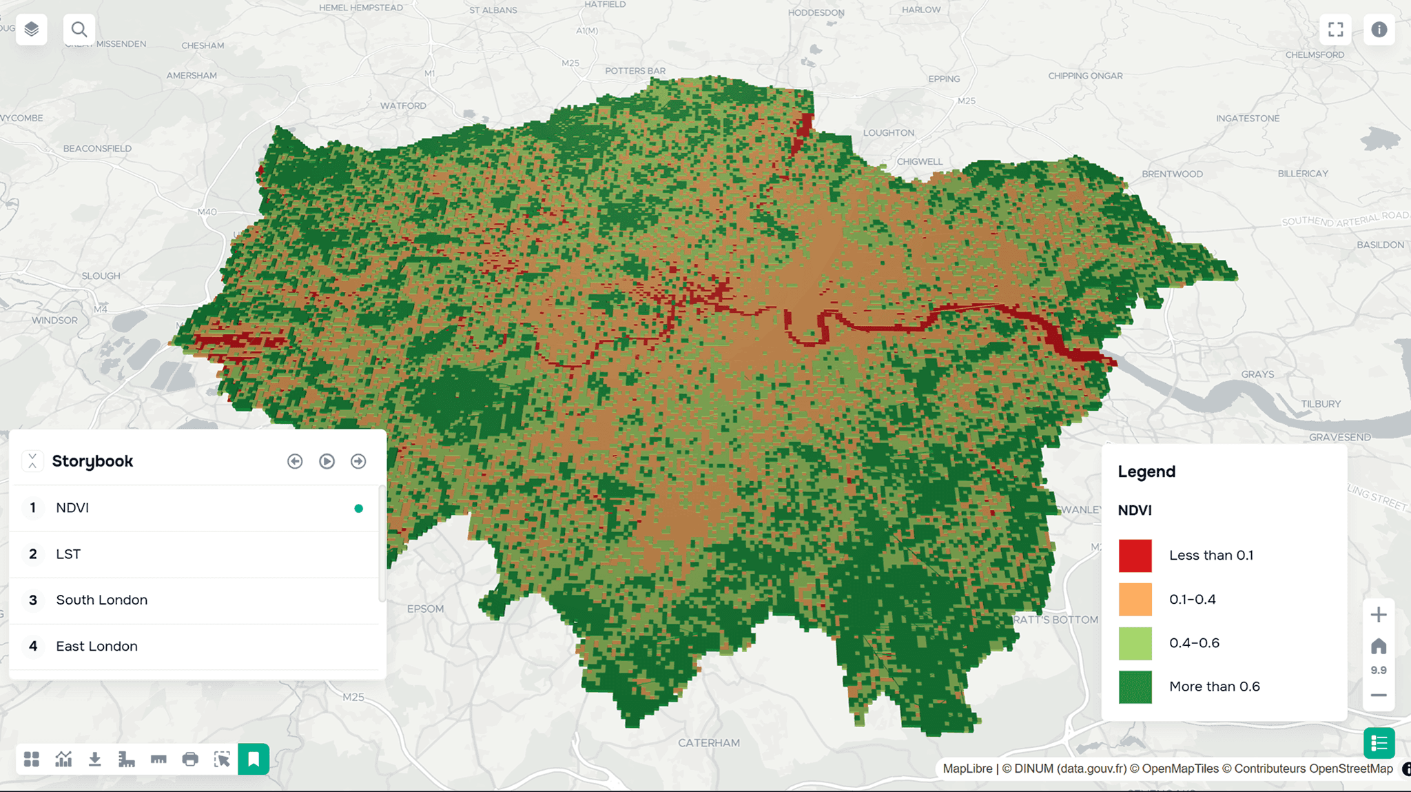
NDVI index for the London area. Created using GISCARTA.
raster analysis
change detection
overlay
time series analysis
These methods allow us to identify changes and assess forest conditions.
Tools
Both desktop and web-based solutions are used to work with forest data. For example, QGIS is suitable for in-depth analysis, processing satellite data, and performing complex spatial operations. For faster visualization and work without setting up an environment, web platforms such as GISCARTA are used, allowing data to be uploaded and analyzed directly in the browser. Google Earth Engine is also used for working with satellite data and large data sets, enabling cloud-based analysis and processing.
FAQ
How is GIS used in forestry?
To monitor forest health, analyze resources, and identify deforestation.
Is it possible to track deforestation in real time?
Partially using satellite data and monitoring services.
What data is most commonly used?
Satellite imagery, climate data, and forest inventory data.
Key Takeaways
GIS allows you to track forest health and changes over time.
Satellite data is the foundation of modern forest monitoring.
Spatial analysis helps make decisions for sustainable forest management.


