
QGIS vs ArcGIS Pro: What Is the Difference?
The biggest difference is the ecosystem behind each application. ArcGIS Pro is Esri's professional desktop GIS and is closely integrated with ArcGIS Online, ArcGIS Enterprise and other Esri products. QGIS is a free and open-source desktop GIS designed to work with a wide range of formats, databases, web services, plugins and external tools.
QGIS vs ArcGIS Pro
Feature | ArcGIS Pro | QGIS |
Platform type | Professional desktop GIS | Open-source desktop GIS |
License | Commercial | Free and open source |
2D mapping | Yes | Yes |
3D visualization | Yes | Yes |
Vector and raster data | Yes | Yes |
Spatial analysis | Extensive built-in tools and extensions | Extensive core tools, Processing and plugins |
Geoprocessing | Geoprocessing framework and ModelBuilder | Processing framework and graphical models |
Automation | Python, ArcPy, ModelBuilder | Python, PyQGIS, Processing |
Extensions | Esri extensions and add-ins | Large community plugin ecosystem |
Database support | Enterprise geodatabase and many other sources | PostGIS and many other sources |
Web GIS integration | ArcGIS Online and ArcGIS Enterprise | QGIS Server and external web services |
Operating systems | Windows | Windows, macOS, Linux |
Typical strength | Enterprise GIS and integrated workflows | Flexibility and open-source workflows |
What Is ArcGIS Pro?
ArcGIS Pro is Esri's professional desktop GIS application. It supports 2D mapping, 3D scenes, data management, geoprocessing, spatial analysis, imagery workflows and publication to ArcGIS Online or ArcGIS Enterprise. Projects can contain maps, scenes, layouts, reports, charts and connections to databases and portals.
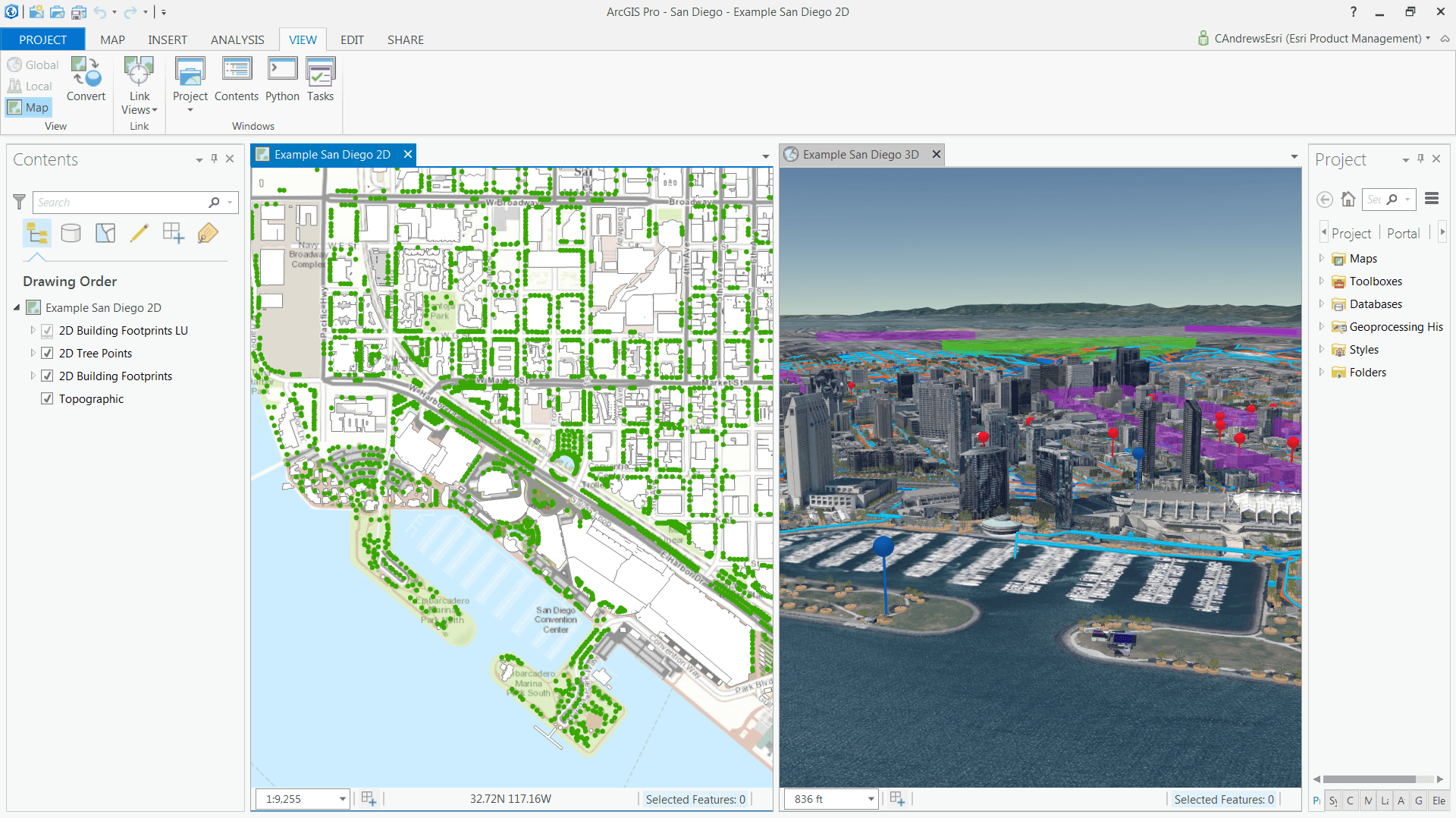
ArcGIS Pro Interface
What Is QGIS?
QGIS is a free and open-source desktop GIS for visualization, editing, analysis and management of spatial data. It supports vector and raster formats, spatial databases, web services, 2D and 3D visualization, and a wide range of cartographic workflows.
A major strength of QGIS is extensibility. The Processing framework, Python console and PyQGIS API can be combined with community plugins and external libraries to build specialized workflows.
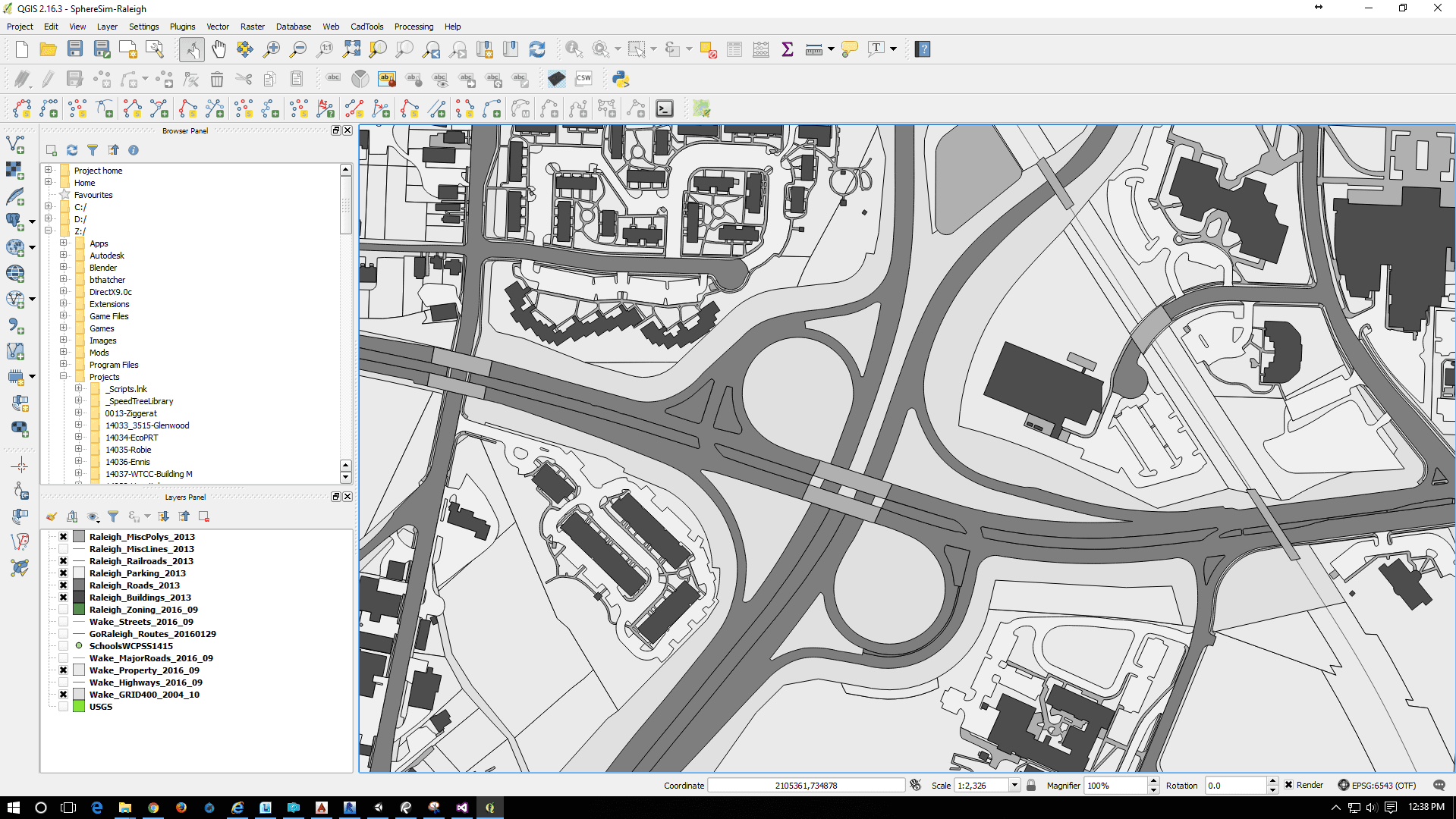
QGIS Interface
Spatial Analysis: QGIS vs ArcGIS Pro
Both platforms can perform a broad range of GIS analysis, including overlays, buffers, spatial joins, raster processing, terrain analysis and statistics. ArcGIS Pro provides a large integrated geoprocessing environment and specialized extensions for areas such as raster, 3D and network analysis.
QGIS provides its own processing tools and can also integrate providers such as GRASS GIS, SAGA and other tools, depending on the installed environment. Plugins can add further specialized functions. For many standard GIS operations, the practical difference is less about whether an operation is possible and more about the available workflow, interface and surrounding tools.
Automation and Python
Automation is supported in both platforms. ArcGIS Pro uses Python and ArcPy for scripting geoprocessing and GIS operations, while ModelBuilder provides a visual way to build repeatable workflows.
QGIS provides Python, PyQGIS and Processing, allowing users to automate tasks and connect GIS operations with external Python libraries. Its open architecture makes it particularly convenient when a workflow needs to combine GIS operations with other open-source tools.
Cartography and Visualization
Both applications provide advanced symbology, labeling, layouts and export capabilities. ArcGIS Pro has a strong integrated cartographic environment with 2D and 3D visualization, animation and temporal mapping. QGIS offers rich symbology, data-defined styling, print layouts, atlas generation and 3D visualization.
For many cartographic projects, both can produce publication-quality results. The difference is usually the styling workflow and the tools a user is already familiar with rather than the fundamental quality of the final map.
Data and Interoperability
QGIS is often chosen for interoperability because it supports many open and proprietary GIS formats, databases and OGC services and can be extended through plugins. This makes it convenient when a project combines data from different organizations and software environments.
ArcGIS Pro also supports a wide range of data sources, but it provides additional capabilities and structures specific to the ArcGIS ecosystem, especially around geodatabases, portals and hosted services. The better choice depends on whether the project benefits more from open interoperability or from a unified vendor environment.
Publishing and Web GIS
ArcGIS Pro has a direct publishing workflow to ArcGIS Online and ArcGIS Enterprise. This makes it straightforward to move from desktop maps and analysis into hosted web maps, scenes and applications within the Esri ecosystem.
QGIS can publish maps and services through QGIS Server and can connect to many external web services. It can also be combined with web GIS platforms when a project needs a browser-based interface. This gives QGIS more freedom in choosing the web technology around the desktop workflow.
Licensing and Cost
QGIS is free and open source, so there is no commercial software license fee for using the application. Organizations may still have costs for infrastructure, support, hosting, training or custom development.
ArcGIS Pro uses commercial licensing through Esri user types and license levels. Its cost should therefore be evaluated together with the value of the wider ArcGIS ecosystem, including ArcGIS Online, ArcGIS Enterprise, extensions and organizational tools.
Common Mistakes
A common mistake is to judge the platforms only by the number of tools. Both are capable of handling serious GIS work, and the relevant question is which workflow is easier to maintain for the project.
Another mistake is treating QGIS as only an educational or lightweight GIS. Its Processing framework, plugins, Python support, database integration and external providers make it suitable for complex professional workflows.
It is also easy to overlook the ecosystem effect. ArcGIS Pro can be especially valuable when an organization already relies on ArcGIS Online or ArcGIS Enterprise, while QGIS can be especially attractive when users need freedom to combine different technologies.
FAQs
Is QGIS as powerful as ArcGIS Pro?
For many common GIS tasks, both platforms provide comparable capabilities. ArcGIS Pro has a particularly broad commercial ecosystem and specialized extensions, while QGIS combines strong core functionality with plugins, Processing and external providers.
Is QGIS completely free?
Yes. QGIS is free and open-source software. There is no commercial license fee for downloading and using the desktop application.
Can QGIS replace ArcGIS Pro?
For many projects, yes. QGIS can handle mapping, editing, analysis, automation, databases and web services. Organizations that depend on specific Esri extensions or enterprise workflows may still prefer ArcGIS Pro.
Can QGIS and ArcGIS Pro be used together?
Yes. They can exchange common formats and connect to many of the same databases and web services. A practical workflow may use each application for the tasks it handles best.
Which is better for beginners?
QGIS can be an accessible starting point because it is free and has no commercial license barrier. ArcGIS Pro provides a structured professional environment and extensive official documentation and training, but access depends on licensing.
Key Takeaways
ArcGIS Pro and QGIS are both powerful desktop GIS applications, but they follow different models. ArcGIS Pro is part of a commercial ecosystem that connects desktop GIS with web GIS, enterprise infrastructure and specialized Esri products. QGIS emphasizes openness, interoperability and extensibility through plugins, Python, databases and external GIS tools.
The right choice depends on the project. For organizations already operating an Esri-based GIS environment, ArcGIS Pro can provide a highly integrated workflow. For users who prioritize openness, flexibility and freedom from software license fees, QGIS is a strong alternative.



