
ArcGIS Online vs GISCARTA: What Is the Difference?
ArcGIS Online and GISCARTA are both web-based GIS platforms for creating interactive maps, working with spatial data and sharing projects through a browser.
Quick Answer
Choose ArcGIS Online when you need a large enterprise GIS ecosystem, extensive application options, advanced analysis and tight integration with ArcGIS Pro and other Esri technologies.
Choose GISCARTA when you need a focused web GIS workflow for interactive maps, dashboards, visualization and practical spatial analysis without building a larger ArcGIS environment.
For many projects, the choice depends less on which platform has more tools and more on how much GIS infrastructure the project actually requires.
ArcGIS Online vs GISCARTA
Feature | ArcGIS Online | GISCARTA |
|---|---|---|
Platform type | Cloud GIS platform | Web GIS platform |
Interactive maps | Yes | Yes |
Hosted spatial data | Yes | Yes |
Vector data | Yes | Yes |
Raster data | Yes | Yes |
3D visualization | Yes, through Scene Viewer | Yes |
Spatial analysis | Extensive tools within the ArcGIS ecosystem | Practical web-based analysis and widgets |
Dashboards | ArcGIS Dashboards | Built-in dashboards |
Web applications | Multiple app builders | Interactive maps, widgets and project elements |
External data | ArcGIS services, OGC and other sources | WMS, WFS, WMTS, ArcGIS and other external sources |
Collaboration | Organizations, groups and role-based access | Sharing and collaboration features |
Desktop integration | Strong integration with ArcGIS Pro | QGIS plugin and web workflow |
Licensing | Annual user types plus credits for certain operations | Subscription plans |
Best suited for | Enterprise GIS | Fast web mapping |
What Is ArcGIS Online?
ArcGIS Online is Esri's cloud-based GIS platform for creating maps, managing spatial content, performing analysis and publishing web maps and applications. It provides hosted layers, web maps, dashboards, 3D scenes and application-building tools in a browser-based environment.
A major strength of ArcGIS Online is its connection to the broader ArcGIS ecosystem. Organizations can use it together with ArcGIS Pro and other ArcGIS applications, while administrators can manage members, roles, permissions and shared content in a common organization.
ArcGIS Online also provides access to ArcGIS Living Atlas and other ready-to-use content, which can speed up projects that need authoritative or contextual datasets..
What Is GISCARTA?
GISCARTA is a web GIS platform for building interactive maps, dashboards and geospatial analysis directly in a browser. Users can upload spatial data, connect external sources, configure layer styles, add widgets and publish the resulting project online.
The platform supports common GIS formats and external services such as WMS, WFS, WMTS and ArcGIS services. This makes it possible to combine local datasets with information already published by external GIS servers.
GISCARTA also provides functional widgets for dashboards, statistics, transport analysis, geospatial processing and other web-based workflows, depending on the selected plan.
Data Analysis: ArcGIS Online vs GISCARTA
ArcGIS Online provides a broad set of analysis tools in the ArcGIS ecosystem. Map Viewer includes spatial analysis capabilities, while the wider ArcGIS platform adds more specialized tools through ArcGIS Pro and other products. Some ArcGIS Online operations use credits, particularly certain storage and analysis services.
GISCARTA focuses on practical analysis that can be performed as part of an interactive web project. Depending on the plan, users can work with statistics, transport analysis, geospatial processing and other functional widgets directly in the browser.
For highly specialized or multi-stage GIS analysis, ArcGIS has the broader toolchain. For analysis that is closely tied to an interactive web map, GISCARTA offers a more focused workflow.
Publishing and Collaboration
Both platforms are designed for sharing GIS results online rather than keeping the final product on a local workstation.
ArcGIS Online provides an organizational model based on users, groups, roles and permissions. Maps, layers, dashboards and applications can be shared with specific members, groups, an organization or the public, depending on access settings.
GISCARTA is also built around web publication. Projects can be shared as interactive maps and dashboards and can be embedded or used as part of a web-based geoportal. The workflow emphasizes getting the finished map into a browser and making it accessible to colleagues, clients or other audiences.
Integration and Data Sources
ArcGIS Online naturally fits into Esri workflows. It can work with ArcGIS Pro, hosted feature layers, ArcGIS services and other components of the ArcGIS ecosystem. It also supports interoperability with external services and common GIS data sources.
GISCARTA can connect external GIS services directly to a project. Its external source workflow supports ArcGIS Server, GeoServer and external WMS/WMTS sources, while WFS layers can be styled within the project.
This makes the two platforms compatible with many of the same web-service concepts, but the role they play is different: ArcGIS Online is the web component of a larger proprietary GIS ecosystem, while GISCARTA is a more focused web GIS environment.
Using ArcGIS Online and GISCARTA Together
The two platforms do not necessarily have to be treated as mutually exclusive. A project can use ArcGIS Online as a source of hosted or published ArcGIS services while GISCARTA serves as the environment for a separate interactive web map or presentation layer.
This approach is useful when data already exists in the ArcGIS ecosystem but the final web experience is being built in another platform. GISCARTA can connect to compatible ArcGIS services through its external data-source workflow, reducing the need to duplicate data manually.
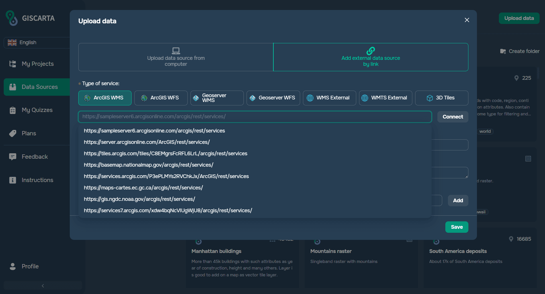
Adding an ArcGIS WMS Layer as an External Source in GISCARTA
Common Mistakes
A common mistake is comparing the platforms only by the number of visible tools. ArcGIS Online is part of a much larger ecosystem, so its value often comes from integration between products rather than from a single web map interface.
Another mistake is treating every GIS project as an enterprise GIS deployment. If the actual requirement is to publish an interactive map or dashboard quickly, a focused web GIS workflow may be sufficient.
It is also important to consider licensing before choosing a platform. In ArcGIS Online, user types and credit-consuming services can affect the project model. In GISCARTA, the plan determines limits and available functionality.
How to Choose
Choose ArcGIS Online when your project depends on the broader ArcGIS ecosystem, organizational user management, extensive web application options, advanced analysis or integration with ArcGIS Pro.
Choose GISCARTA when your priority is fast web publication, interactive visualization, dashboards, practical web analysis and a straightforward browser-based workflow.
If your team already has a large Esri infrastructure, ArcGIS Online may be the natural extension of that environment. If the main goal is to move from spatial data to an interactive web project with minimal overhead, GISCARTA may be the more direct choice.
FAQs
Is GISCARTA an alternative to ArcGIS Online?
Yes, for many web-mapping and interactive GIS tasks. Both platforms can publish maps, work with spatial data and support analysis. However, ArcGIS Online is part of a much broader Esri ecosystem, so the platforms are not identical in scope.
Can ArcGIS Online data be used in GISCARTA?
Yes, when the data is exposed through compatible ArcGIS services. GISCARTA supports ArcGIS Server as an external source, along with WMS, WFS and WMTS connections.
Does ArcGIS Online require ArcGIS Pro?
No. ArcGIS Online is a cloud service that can be used in a browser. ArcGIS Pro is optional, but the integration between the two can be valuable when a project uses desktop GIS for data preparation or advanced analysis.
Which platform is easier for a simple interactive map?
For a project centered on uploading data, styling layers, adding widgets and publishing a web map, GISCARTA can provide a more direct workflow. ArcGIS Online offers a broader environment, which may be more than is necessary for a small standalone project.
Which platform is better for an enterprise GIS?
ArcGIS Online is generally the stronger choice when the web platform must work as part of a wider enterprise ArcGIS environment with multiple user types, applications, services and desktop integrations.
Key Takeaways
ArcGIS Online and GISCARTA solve many of the same web-GIS problems, but they approach them from different directions.
ArcGIS Online is a broad cloud GIS ecosystem designed to support mapping, analysis, applications, collaboration and integration across Esri products.
GISCARTA is a focused web GIS platform designed to move spatial data into interactive maps, dashboards and web-based analytical projects with a direct workflow.
The better choice depends on the project's scale, required integrations, analytical depth, collaboration model and licensing requirements.



