
Quick Answer
Choose QGIS when you need deep control over geodata, advanced processing, desktop editing, a large ecosystem of plugins and support for many local and database formats.
Choose GISCARTA when you need to turn geodata into an interactive web map, dashboard or shared project without installing desktop GIS software.
For many projects, the best workflow is to use both: prepare or analyze data in QGIS and publish, share or present the result in GISCARTA.
QGIS vs GISCARTA
Category | QGIS | GISCARTA |
|---|---|---|
Type | Desktop GIS | Web GIS platform |
Installation | Desktop application | Runs in a web browser |
Data work | Create, edit, manage and export data | Upload and manage project layers |
Analysis | Advanced geoprocessing, raster/vector analysis, GRASS and third-party algorithms | Practical built-in geospatial tools and widgets |
Customization | Plugins, Python and extensive desktop configuration | Platform tools, widgets and configurable projects |
Publishing | Can publish through QGIS Server and related OGC services | Publish interactive maps and dashboards from the platform |
Collaboration | Usually requires additional infrastructure and workflows | Designed around shared web maps and team workflows |
Best suited for | Data preparation, editing and complex analysis | Web mapping, dashboards, communication and shared GIS workflows |
Access | Primarily local desktop access | Browser-based access and sharing |
Cost | Free and open source | Free tier plus paid plans |
This is not a direct feature-for-feature comparison. QGIS and GISCARTA overlap in mapping and analysis, but their core operating models are different: one is desktop-first, the other is web-first.
What Is QGIS?
QGIS is a free and open-source desktop GIS used to view, edit, analyze and share spatial data. Its official documentation highlights support for vector and raster data, 2D and 3D visualization, spatial databases, OGC web services, geoprocessing and Python-based extension. The Processing framework can call native and third-party algorithms, including GDAL, GRASS, SAGA, OTB and R.
QGIS is especially strong when the GIS task starts with the data itself. You can inspect raw layers, change geometries, manage attribute tables, build repeatable processing workflows, connect to databases and install plugins for specialized tasks.
What Is GISCARTA?
GISCARTA is a web GIS platform for building interactive maps, dashboards and geospatial analysis in a browser. The platform is designed around adding spatial data, styling layers, using built-in tools and widgets, and then publishing the result as a web map or dashboard.
GISCARTA supports common GIS data formats and provides tools for mapping, analysis, 3D visualization, dashboards and external data connections. Its web-based workflow means that users can open and share projects without installing a desktop GIS application.
The platform also offers a QGIS plugin that can export vector and raster layers directly from QGIS to GISCARTA, making the two tools complementary rather than mutually exclusive.
The Key Difference
The main difference is the working environment. QGIS is designed around direct work with geospatial data on the desktop. GISCARTA is designed around turning geospatial data into an accessible web project.
That changes the workflow. In QGIS, you normally build the data and analysis first, then decide how to publish it. In GISCARTA, publishing and sharing are part of the project workflow itself.
A simple way to think about it:
QGIS is a strong choice for building and analyzing GIS data.
GISCARTA is a strong choice for publishing, presenting and sharing GIS work on the web.
Data Analysis: QGIS vs GISCARTA
QGIS has the broader analytical toolset. Its Processing framework supports native and third-party algorithms, and its integration with GRASS adds hundreds of modules. It also provides a graphical modeler for chaining operations.
GISCARTA focuses on practical analysis inside a web project. Depending on the plan and enabled tools, this can include measurements, buffers, transport analysis, statistics, dashboards, elevation-related tools and other widgets. The emphasis is on answering common spatial questions and communicating the result rather than reproducing the full desktop geoprocessing environment.
Publishing and Collaboration
This is where the two platforms differ most clearly. QGIS can publish maps through QGIS Server and supports many OGC services as a client, but turning a desktop project into a web service can require additional server-side setup.
GISCARTA is web-first: projects are created in the browser and can be published as interactive maps and dashboards. The platform also supports sharing workflows, including view-only maps and collaborative access in appropriate plans.
Using QGIS and GISCARTA Together
There is no need to choose one platform for every stage of a GIS project. A practical workflow is to use QGIS for detailed data preparation and analysis, then move the results to GISCARTA for web publication, visualization and sharing. The GISCARTA QGIS plugin makes this workflow easier by connecting QGIS directly with the platform, allowing users to transfer layers between the two environments and continue working with them in GISCARTA. The plugin can be installed using the GISCARTA QGIS Plugin installation guide.
This makes it possible to prepare and analyze data in QGIS and then quickly bring the resulting layers into GISCARTA, where they can be configured for a web map, styled and combined with basemaps, widgets and other project elements. For example, a team can clean and analyze a road network in QGIS, transfer the resulting layer to GISCARTA using the plugin, configure its appearance and publish the finished interactive map for colleagues or clients.
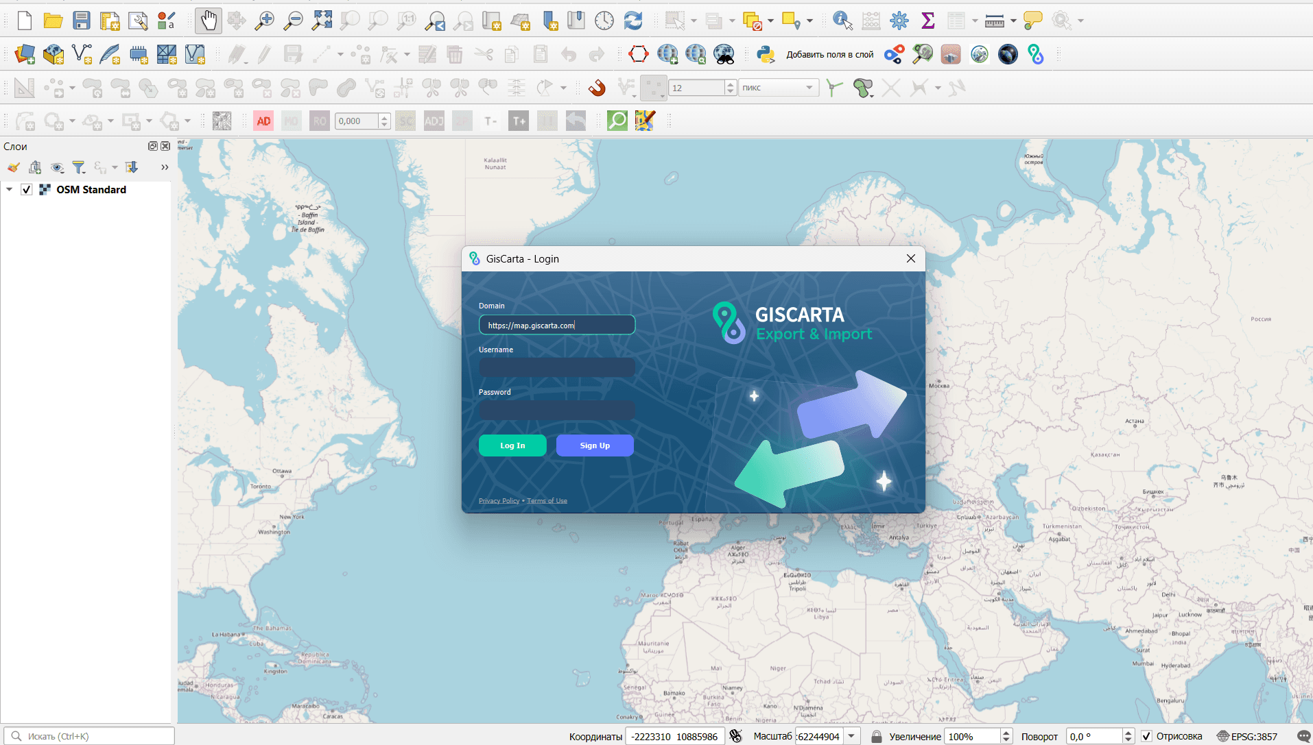
GISCARTA plugin for QGIS
Common Mistakes
Treating QGIS and GISCARTA as direct substitutes in every workflow.
Choosing a platform before deciding whether the main task is data preparation or web publication.
Expecting a browser GIS to reproduce every specialized desktop GIS workflow.
Assuming that a powerful desktop analysis environment automatically provides an easy public-facing web map.
Ignoring the possibility of using QGIS and GISCARTA together.
How to Choose
Need detailed editing and geoprocessing → QGIS.
Need a web map or dashboard that is easy to share → GISCARTA.
Need plugins, Python and a broad desktop ecosystem → QGIS.
Need browser access without desktop installation → GISCARTA.
Need both advanced analysis and web publication → Use QGIS for preparation and GISCARTA for publishing.
FAQs
Is GISCARTA a replacement for QGIS?
Not in every workflow. QGIS offers a broader desktop GIS environment for data editing, processing, plugins and advanced analysis. GISCARTA addresses a different need: creating and sharing interactive web GIS projects. For many teams, they work well together.
Is QGIS better than GISCARTA?
It depends on the task. QGIS is generally better suited to detailed data preparation and advanced desktop analysis. GISCARTA is better suited to browser-based mapping, publishing, dashboards and sharing. There is no single winner across all GIS workflows.
Can I use QGIS data in GISCARTA?
Yes. GISCARTA supports common spatial formats, and its QGIS plugin can export vector and raster layers directly from QGIS to the platform.
Do I need to install QGIS to use GISCARTA?
No. GISCARTA is browser-based. QGIS is useful when you need desktop GIS capabilities, but it is not required for creating and sharing a GISCARTA web project.
Which is better for a public interactive map?
GISCARTA is usually the more natural choice because publishing and sharing interactive web maps are part of its core workflow. QGIS can also support web publication, but typically through additional setup such as QGIS Server.
Key Takeaways
QGIS is a desktop GIS; GISCARTA is a web GIS platform.
QGIS is stronger for detailed editing, geoprocessing, plugins and advanced data workflows.
GISCARTA is stronger for interactive web maps, dashboards, sharing and browser-based workflows.
Neither platform replaces the other in every situation.
A QGIS → GISCARTA workflow can combine advanced desktop processing with simple web publication.



