
Imagine that you have temperature measurements from hundreds of weather stations across Europe. Each station provides information only for its specific location, but how can we estimate temperature in areas where no measurements exist?
Spatial interpolation is one of the most widely used techniques in geographic information systems. It allows analysts to estimate values at unmeasured locations based on observations collected at nearby points.
What is spatial interpolation?
Spatial interpolation is a method for estimating values at unknown locations using known observations from surrounding points.
The concept is based on Tobler's First Law of geography:
Everything is related to everything else, but near things are more related than distant things.
Common spatial interpolation methods
Spatial interpolation methods are commonly divided into two large categories:
Deterministic methods
Geostatistical methods
1. Deterministic methods
These methods use the measured values in the vicinity of the interpolated point and apply a mathematical formula to them.
IDW (Inverse Distance Weighted)
The most common method in GIS programs
The closer the point, the greater its weight
Easy to understand and apply
Spline
Creates a smooth surface
Good for smooth changes
Create extreme values
Natural Neighbor
Based on Voronoi diagrams
Does not create extreme values
2. Geostatistical methods
Based on statistical models that include analysis of autocorrelation (statistical relationships between measured points).
Kriging
The most powerful and flexible method
Takes into account spatial autocorrelation
Provides an estimate of the prediction error
Empirical Bayesian Kriging
Advanced version of kriging
Automates parameter selection
Comparison of methods
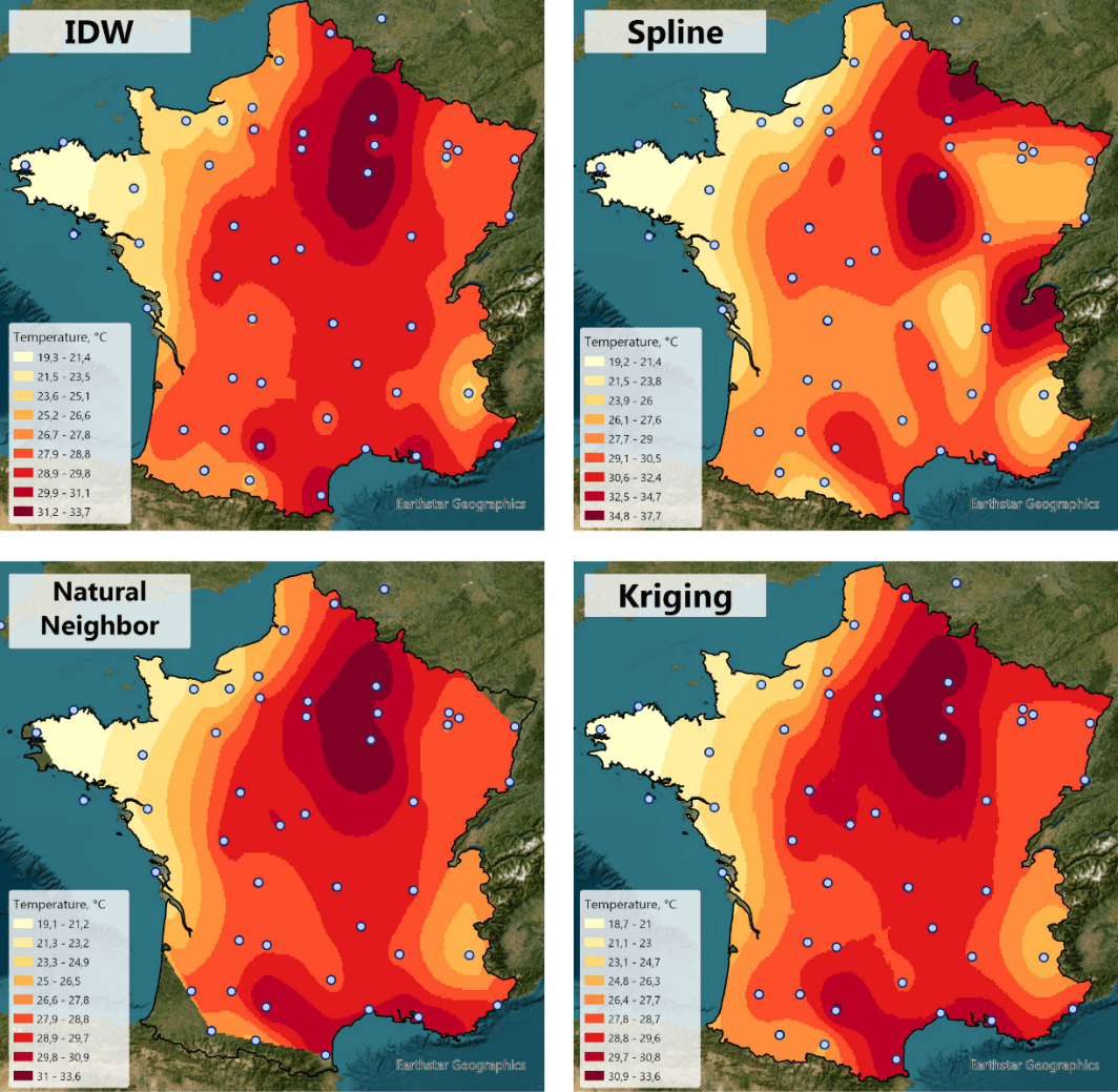
Comparison of air temperature interpolation results obtained using IDW, Spline, Natural Neighbor and Kriging methods.
Method | Advantages | Disadvantages | When to use it |
IDW | Simplicity, speed, intuitiveness | "Bull's eye effect" | Fast interpolation, uniform distribution of points |
Spline | Smooth surface, aesthetically pleasing appearance | May produce unrealistic extrema | Smooth surfaces (elevation, temperature) |
Natural Neighbor | Accuracy, no artifacts | Slower than IDW | Uneven distribution of points |
Kriging | Statistical rigor, error estimation | Complexity; requires knowledge of geostatistics | Critical projects, scientific research |
Where is spatial interpolation used?
Meteorology and climatology
Creating temperature, precipitation, and pressure maps
Climate modeling and weather forecasting
Drought and extreme weather analysis
Ecology and environmental protection
Mapping air, water, and soil pollution levels
Monitoring habitat quality and biodiversity
Assessing environmental risks and contamination spread
Geology and mining
Estimating mineral reserves and ore grades
Creating subsurface geological models
Groundwater resource evaluation
Agriculture
Soil fertility and nutrient mapping
Precision farming and yield prediction
Irrigation planning and moisture monitoring
Hydrology
Groundwater level mapping
Water quality assessment across watersheds
Flood risk modeling and surface water analysis
Healthcare
Disease outbreak mapping and epidemiology
Healthcare accessibility analysis
Environmental health risk assessment
Urban Planning
Noise pollution mapping
Property value surface modeling
Infrastructure planning and service area analysis
FAQ
Can interpolation be performed beyond the study area?
Extrapolation outside the study area is unreliable and should be avoided.
What methods are used to validate interpolation results?
Cross-validation and RMSE (Root Mean Square Error) calculations are used to assess accuracy.
How to handle unevenly distributed points?
Natural Neighbor or Kriging methods are recommended instead of IDW for better results with uneven point distribution.
Key Takeaways
Spatial interpolation estimates values at unmeasured locations using nearby data points.
IDW, Spline, Natural Neighbor and Kriging are the most popular methods. Method choice depends on data distribution and project requirements.
Applications span meteorology, ecology, agriculture, healthcare, and urban planning.



