
Web GIS platforms can connect to the same geographic source in very different ways. Sometimes the goal is simply to display an authoritative map layer. In other cases, users need the underlying features, attributes, and the ability to query individual objects. This is where WMS and WFS serve different purposes.
Quick Answer
Choose WMS when your main goal is reliable map display. Choose WFS when users or applications need access to individual vector features and their attributes. If a layer is primarily a reference layer and does not need feature-level interaction, WMS is often the more appropriate choice. If the workflow depends on querying or analyzing vector objects, WFS is usually the better fit.
WMS vs WFS
Category | WMS | WFS |
What it delivers | Rendered map image | Vector features and feature properties |
Typical output | PNG, JPEG and other image formats | Feature data, commonly encoded as GML or another supported format |
Best for | Reference maps and authoritative visualization | Querying, filtering and data-driven interaction |
Where rendering happens | Primarily on the server | Features are delivered to the client, which can render or process them |
Feature-level access | Limited; map image is the main result | Yes, at feature/property level |
Data exposure | Underlying feature data is not normally delivered | Feature geometry and attributes can be exposed |
Typical concern | Expecting an image service to behave like a vector layer | Transferring or rendering too many features |
What Is WMS?
WMS stands for Web Map Service. The service receives a request describing the requested layer, geographic extent, coordinate reference system, image size and other parameters, and returns a georeferenced map image. The OGC specification explicitly describes WMS as an HTTP interface for requesting geo-registered map images.
This makes WMS especially useful when the map itself is the product. A server can apply the layer's styling, labels and cartographic rules and send the resulting image to a web GIS client. The client does not need to download every road, building or polygon just to display the map.
When WMS Is a Good Choice
Displaying authoritative reference layers such as administrative boundaries, infrastructure, environmental maps or thematic cartography.
Combining several remote map services in one web map.
Keeping the cartographic rendering on the server while the client mainly handles navigation and display.
Publishing large or complex datasets when users primarily need visualization rather than feature-level analysis.
A key limitation is that the normal WMS response is an image, not a vector feature collection. Some WMS implementations support GetFeatureInfo, which can return information about a location or map feature, but this should not be confused with full feature access provided by WFS.
What Is WFS?
WFS stands for Web Feature Service. Instead of returning only a picture of the map, WFS provides direct access to geographic features and their properties. The OGC specification defines discovery and query operations at the feature and feature-property level; transactional capabilities also exist in WFS, although support depends on the particular service.
For a web GIS, this means that a layer connected through WFS can contain actual point, line or polygon geometries together with attributes. The client can then query, filter, symbolize or analyze those features, depending on the capabilities of the platform and service.
When WFS Is a Good Choice
Working with vector objects rather than only a visual representation of them.
Filtering features by attributes or spatial conditions.
Building data-driven maps where the client needs feature geometry and properties.
Using external vector data as an input for further GIS analysis, where supported.
Connecting web applications to a feature service that needs more than simple map display.
Using WMS and WFS Together
WMS and WFS are not mutually exclusive. In many GIS workflows, the same underlying dataset can be published through both services, with each service serving a different purpose.
For example, a municipal GIS could use WMS to display a detailed road network as a stable reference layer, while WFS provides selected road features and attributes for analysis. The web map can then use WMS for the broad visual context and WFS only where feature-level interaction is actually needed.
This hybrid approach can reduce unnecessary data transfer while preserving the analytical capabilities of vector data.
Comparison of one earthquake layer added in different ways
WMS and WFS in GISCARTA
GISCARTA can work with external geospatial services as part of a web GIS workflow. In the external-source interface, users can connect ArcGIS WMS, ArcGIS WFS, GeoServer WMS, GeoServer WFS, as well as external WMS and WMTS sources. This makes it possible to bring remote GIS services into a single web map without first converting every dataset into a local layer, as also noted in "Adding External Data Sources to Maps: A Guide to Web Mapping Services"
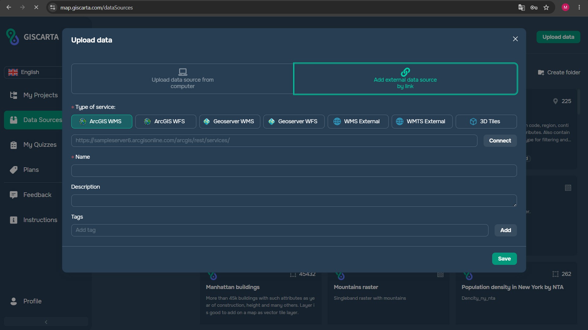
Adding external data sources to GISCARTA
For WMS connections, the practical use case is usually straightforward: add an external map service and use it as a visual layer. For WFS, the important advantage is access to vector features and their attributes, which can support richer feature-level interaction where the GISCARTA workflow and the service capabilities allow it.
Common Mistakes
Choosing WFS simply because it sounds more powerful, even though users only need a reference map.
Choosing WMS and then expecting to receive the original vector geometry and full attribute table.
Assuming every WFS service is editable. Transactional operations are part of the WFS standard, but a particular published service may be read-only or may not support transactions.
Comparing WMS and WFS only by theoretical speed without testing the actual dataset and workflow.
Ignoring the amount of feature data that a WFS request can return.
Publishing sensitive attributes through WFS without considering the intended audience and access policy.
How to Choose: A Simple Decision Framework
Do users mainly need to see the map? → Start with WMS.
Do users need individual features and attributes? → Consider WFS.
Do users need to filter or query vector features? → WFS is usually the better fit.
Do users need a stable cartographic reference layer? → WMS is usually the simpler choice.
Do you need both visualization and feature access? → Consider publishing or connecting both, with each service used for its specific role.
FAQs
Is WMS better than WFS?
Neither is universally better. WMS is better suited to map visualization, while WFS is designed for feature-level access.
Can WMS provide feature information?
Some WMS services support GetFeatureInfo, allowing a client to request information associated with a location on the map. However, WMS still primarily delivers rendered map images and should not be treated as a replacement for a feature service.
Is WFS editable?
Not necessarily. WFS includes transactional operations in the standard, but whether editing is available depends on the particular service and its configuration.
Can I use WMS and WFS in the same project?
Yes. Using WMS for visualization and WFS for selected feature-level workflows can be a practical combination.
Which should I choose for GISCARTA?
If you only need to display an external map, WMS is usually the natural starting point. If you need access to the underlying vector features and attributes, investigate WFS and the capabilities of the specific service you are connecting.
Key Takeaways
WMS delivers a rendered map image; WFS provides access to vector features and their properties.
WMS is usually the better fit for reference visualization, while WFS is better for feature-level queries and data-driven interaction.
WFS does not automatically mean editing: transactional support depends on the service.
Performance depends on the real workflow and dataset, not only on the service name.
WMS and WFS can be used together when visualization and feature access are separate requirements.
GISCARTA supports multiple external GIS service types, making it possible to integrate remote sources into a web GIS workflow.



