
Spatial Join is one of the most commonly used spatial analysis tools in GIS. It allows you to combine data from different layers based on their spatial location rather than a common attribute. This allows you to determine which features intersect, are located within other features, or are closest to each other.
Spatial Join is widely used in urban planning, logistics, business analytics, ecology, and many other areas where it is important to analyze the relative positions of features on a map.
How Spatial Join Works
Two layers are used to perform a spatial join:
Target Layer: the layer that will receive the new attributes.
Join Layer: the layer from which the data will be transferred.
The tool analyzes the spatial relationships between features in the two layers and transfers attributes according to the selected join rule.
For example, if you have a building layer and a zoning layer, Spatial Join can determine which zoning each building is in and add the corresponding information to the buildings attribute table.
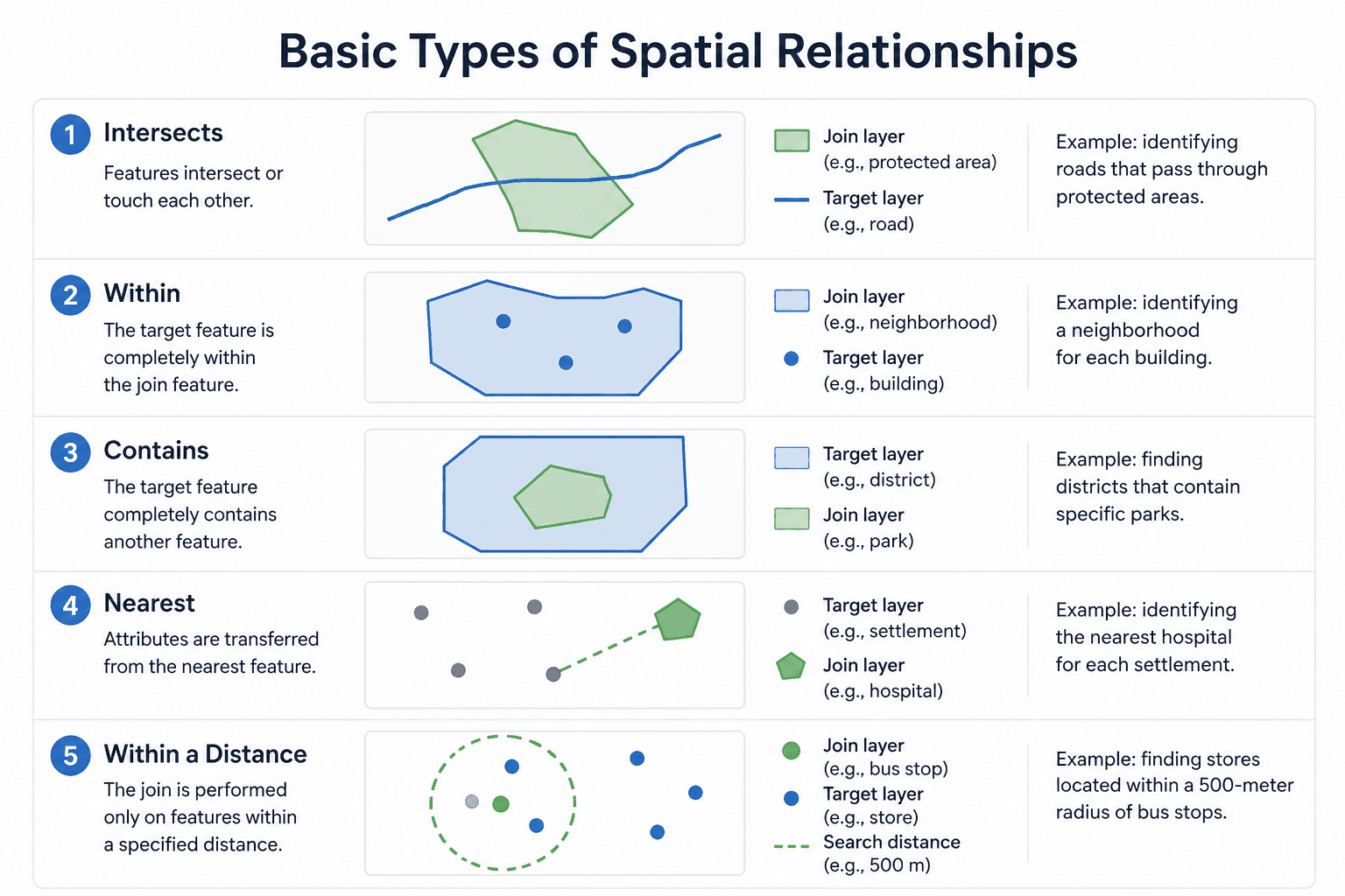
Basic Types of Spatial Relationships
The result of a Spatial Join depends on the selected spatial relationship.
Intersects. The join is performed on features that intersect or touch each other.
Example: identifying roads that pass through protected areas.
Within. The target layer feature must be completely contained within the feature of the joining layer.
Example: identifying a neighborhood for each building.
Contains. The target layer feature completely contains another feature.
Example: finding neighborhoods containing specific infrastructure facilities.
Nearest. Attributes are transferred from the nearest feature.
Example: identifying the nearest hospital for each settlement.
Within a Distance. The join is performed only on features within a specified distance of each other.
Example: finding features located within a 500-meter radius of bus stops.
Spatial Join in Popular GIS
Most modern GIS systems include built-in spatial join tools.
ArcGIS Pro. ArcGIS uses the Spatial Join tool, which supports various spatial relationships, statistical operations, and data aggregation options.
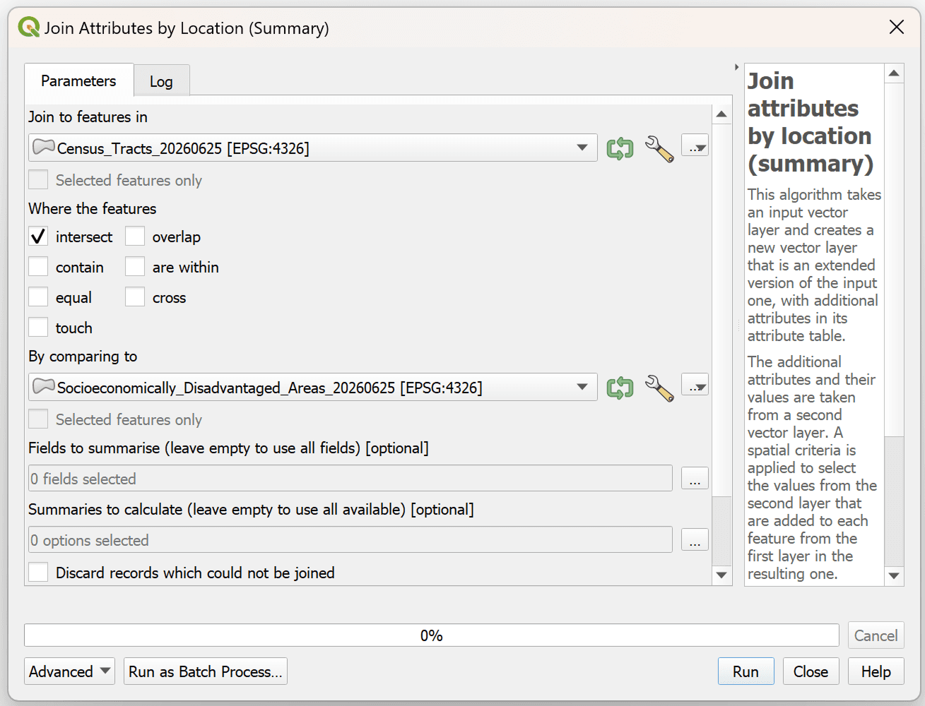
QGIS. QGIS offers the Join Attributes by Location and Join Attributes by Nearest tools, which allow you to perform spatial joins using various rules.
One-to-One and One-to-Many Joins
When performing a Spatial Join, it's important to understand the difference between the two types of joins.
One-to-One. Each feature in the target layer corresponds to only one record from the joining layer.
For example, each building belongs to only one administrative district.
One-to-Many. One feature in the target layer can correspond to multiple features in the joining layer.
For example, a single district may contain many restaurants, stores, or public transportation stops.
Aggregation and Statistics
Spatial Join is often used not only to transfer attributes but also to calculate statistics.
It can be used to:
count the number of objects within a polygon;
sum attribute values;
calculate averages;
find minimum and maximum values;
identify the most common categories.
For example, you can count the number of restaurants in each city district or determine the average population of settlements within administrative regions.
Limitations and Potential Problems
Despite its ease of use, Spatial Join has a number of issues that must be considered.
First, the result depends on the selected spatial relationship. An incorrectly chosen rule can lead to erroneous results.
Second, problems can arise when using layers with different coordinate systems. Before performing analysis, it is recommended to ensure that all data uses the same coordinate system.
Furthermore, when working with large volumes of data, the operation can require significant computing resources and processing time.
Furthermore, the quality of the results directly depends on the accuracy of the source data. Geometry errors or inaccurate coordinates can cause objects to connect incorrectly.
FAQ
What is a Spatial Join?
Spatial Join is a GIS tool that combines data from different layers based on spatial relationships between features.
How does a Spatial Join differ from a regular join?
A regular join uses a shared attribute, such as an ID or feature name. A Spatial Join uses the location of features on the map.
What is a Spatial Join used for?
It enriches data with spatial information and is the basis for many types of spatial analysis.
Key Takeaways
Spatial Join combines data based on spatial relationships between features.
The most popular relationships are Intersects, Within, Contains, and Nearest.
Spatial Join can be used for data aggregation and statistics calculations.



